U.S. Drought Monitor map shows high levels of drought in Utah
Sep 20, 2018, 6:42 PM | Updated: 6:46 pm
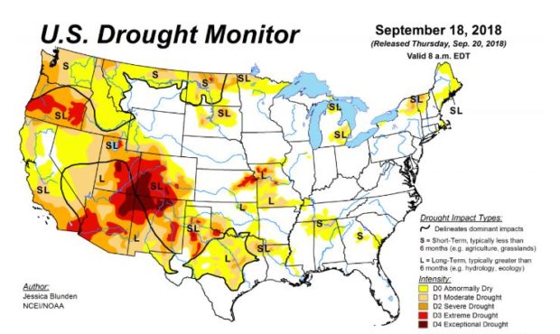
U.S. Drought Monitor map for September 18, 2018 (Courtesy of U.S. Drought Monitor)
(Courtesy of U.S. Drought Monitor)
SALT LAKE CITY — The new U.S. Drought Monitor map is out today, and while most of the East Coast is experiencing little lack of moisture, the story is entirely different on the West Coast.
Specifically looking at Utah on the map, some parts of our state fall into the D4 category, which means “EXCEPTIONAL DROUGHT,” the map’s highest level. Other parts are in D3, “EXTREME DROUGHT,” and the rest is D2 or D1, which is labeled “SEVERE” or “MODERATE.”
September 18: In Utah, extreme drought was introduced to an area east of the Great Salt Lake, encompassing part of the Wasatch-Cache National Forest #UTdrought https://t.co/hs7rCpQMsY #DroughtMonitor #UTwx pic.twitter.com/K4FDgFjnrg
— NOAA NCEI Climate (@NOAANCEIclimate) September 20, 2018
“Utah, right now, is definitely becoming one of the epicenters of drought out west,” says Physical Scientist Jessica Blunden with the National Center for Environmental Information and author of this most recent map.
This probably comes as little surprise after our relatively dry winter last year, but Blunden says the trends aren’t looking favorable.
“It appears that the situation is getting worse, as opposed to getting better,” says Blunden. “You’re still not seeing the rainfall you should be seeing.”
Long-term seasonal forecasts show the likelihood southern Utah will have above-average rainfall, but the situation looks bleak for the rest of the state which could create problems for tourism and industries reliant on reservoirs.