Potential for strong winds as new storm moves into Utah
Apr 4, 2022, 8:45 AM

SALT LAKE CITY — It may not be enough to topple trees or damage rooftops, but there is the potential for strong winds as a new storm moves into Utah on Monday.
KSL Meteorologist Grant Weyman says to look for problems in typical places.
“The areas that we’re really talking about, that could see the strongest winds, would be (the) west desert,” Weyman said.
“So, Tooele Valley and westward, the drive between here (Salt Lake City) and Wendover. Crosswinds for the trucks — 40, 50, 55 miles per hour.”
Weyman says crosswinds, low visibility, and dust are possible for drivers in this area beginning Monday afternoon.
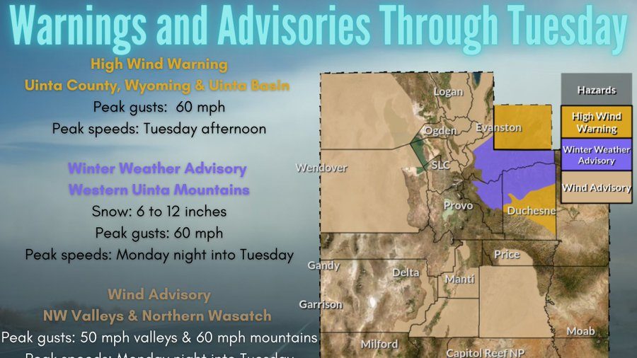
The National Weather Service has posted wind advisories for the western Uintas, as well as for the northern Wasatch Front. Some gusts could approach 60 miles per hour.
High Wind Warnings, Wind Advisories, and Winter Weather Advisories have been issued for Monday afternoon through Tuesday for portions of Utah and southwest Wyoming. Here’s the latest. #utwx #wywx pic.twitter.com/qjtjbt9YBc
— NWS Salt Lake City (@NWSSaltLakeCity) April 4, 2022
Weyman says visibility could be a problem again Tuesday morning, with rain, and blowing snow in some areas.