Meteorologists say Ian’s exact path is still uncertain
Sep 27, 2022, 7:00 AM | Updated: Mar 12, 2023, 6:07 pm
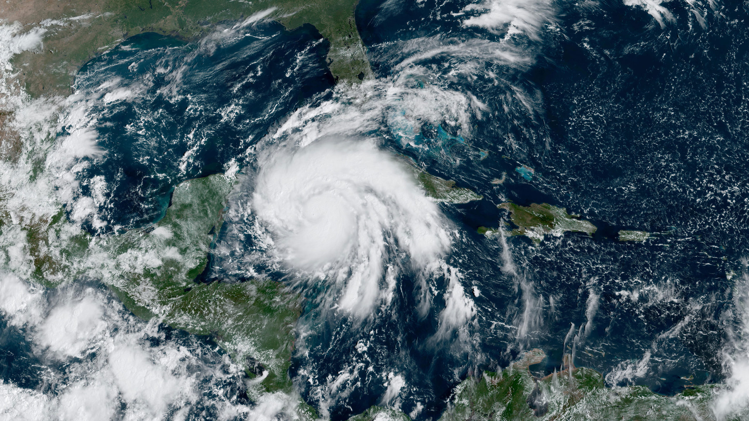
Hurricane Ian could be the storm that the west coast of Florida has always feared -- especially Tampa. Photo credit: NOAA/NASA

(CNN) — Waking up this morning, there’s a sense of dread.
Hurricane Ian could be the storm that the west coast of Florida has always feared — especially Tampa.
One of the cities most vulnerable to hurricanes could face its worst-case scenario.
Tampa is now under a hurricane watch and storm surge watch — and this is just the beginning.
“We tell people even if they’re lifelong Floridians like myself, is this something that we haven’t seen in our lifetime and we definitely need to take it seriously.” said Rick Davis, meteorologist for the National Weather Service in Tampa.
Tampa hasn’t had a direct hit from a hurricane in 100 years, said Davis. It has had several close calls and several brushes with strong storms — but this one is different.
“They (locals) may have a perception of going through a strong storm. But, in reality, the bay area has been missed more often than not,” said Davis.
Right now, Ian is a Category 1 hurricane with winds of 80 mph and higher gusts.
The storm is expected to rapidly strengthen today under ideal conditions for a storm to thrive.
The storm will impact western Cuba tonight and Tuesday as a major Category 3 hurricane.
Storm surge could raise water levels by as much as 14 feet and bring more than a foot of rain to the island.
“These rains may produce flash flooding and mudslides in areas of higher terrain over western Cuba,” the hurricane center warns.
As the storm emerges north of Cuba, forecast models should have a better grasp of what will happens next.
We know the environment around the storm will be one to help the storm maintain its strength, but the question is exactly where the storm will make landfall.
“Regardless of lan’s exact track and intensity, there is a risk of a life-threatening storm surge, hurricane-force winds, and heavy rainfall along the west coast of Florida and the Florida Panhandle by the middle of this week,” said the hurricane center.
More on how Florida is preparing for Hurricane Ian here
If you’re in the path of Ian:
- Make sure you are prepared with our hurricane preparedness checklist
- Bookmark CNN’s lite site in case of low connectivity
- If you were forwarded this email from someone else, sign-up to receive more updates like this one throughout the week.
Storm surge is a real threat
While there is still uncertainty surrounding Hurricane Ian, the National Hurricane Center is currently forecasting 5 to 10 feet of storm surge in Tampa Bay, so residents need to be ready.
“Tampa Bay is a fairly small body of water relative to everything else, but the water will just pile up and pile up and with southeast winds, there’s nowhere for the water to go as the storm slowly moves by,” said Davis. “So, it just continues to pile water into downtown Tampa, which is very vulnerable to storm surge flooding. So that’s definitely a concern for us.”
Davis is hoping that his region takes this storm seriously, prepares, and adheres to the warnings put in place.
Ian will be a force, there’s no doubt about it.
“We’ve had the weekend to prepare, so hopefully people did prepare, and they’re getting the preparations complete, because we’re expecting a life-threatening storm surge in the next 48 to 60 hours,” said Davis. “So just wrap up those preparations, because this is going to be a pretty significant event for the Tampa Bay area.”
Right now, tropical storm-force winds could arrive in South Florida as early as Tuesday, with rain totals ranging anywhere from 4 to 6 inches to nearly a foot and a half of rain further north, hurricane-force winds and, as mentioned above, life-threatening storm surge.
It will not take a direct hit on Tampa to create catastrophic damage from flooding.
Tampa Bay is extremely vulnerable to storm surge, because water being pushed into Tampa Bay has nowhere to go.
“Even in small storms we can get coastal flooding up into the Tampa Bay area, Bayshore Boulevard, and those have been from fairly weak storms, so we can expect with a stronger storm that’s expected to be much closer and slow moving, that will continue to pile up water in areas along the Bay in Tampa and in St. Pete,” said Davis.
Here is why meteorologist say Ian’s exact path is still uncertain
While we know Ian will be strong and will have tremendous impacts, there’s still uncertainty in the storm.
Unfortunately, most of the scenarios are bad for the Tampa Bay area, because it’s so vulnerable.
But the uncertainty in the forecast could make a difference in how bad the devastation could be.
“The computer weather models are only as accurate as the information entered into them,” said CNN meteorologist Chad Myers. “NOAA has been doing everything possible, including extra weather balloon launches and hurricane hunter flights, to increase the accuracy of this data.”
The truth of the matter is that forecast accuracy goes down beyond three and four days out.
The forecast cone has shifted slightly from west to east over the weekend, taking aim at different points along the Gulf Coast.
So, it’s impossible to say at this point exactly where the storm will make landfall, but we do know the effects will stretch much farther and wider than the landfall location — this will be a big, impactful storm.
The hurricane center has noted the uncertainty as well in their forecast discussion this morning.
Agreeing that models are in good agreement on what will happen during the next 48 hours, but beyond that, there’s quite a bit up for debate.
The European forecast models are “on the eastern side of the guidance and show a track very near or over the west-central coast of Florida,” said the hurricane center. While other forecast models are “on the western side with a track toward Appalachia Bay.”
While this may not seem like a huge disparity to some, this could mean the difference in someone getting 100-plus mph winds, or a breezy day — or someone getting nearly 10 feet of storm surge or not much at all — that’s a huge difference.
“An even greater concern is the slower forward motion that is forecast,” the hurricane center said. “This would likely prolong the storm surge, wind, and rainfall impacts along the affected portions of the west coast of Florida, although the roughly shore-parallel track still makes it difficult to pinpoint exactly what locations will experience the most severe impacts.”
Bottom line is that there are some certainties and some uncertainties, so we should prepare for the worst and be ready for anything with Ian.
“It should again be stressed that there is still significant uncertainty in the track of Ian, especially in the three-to-five-day time frame, and users should not focus on the details of the track forecast at longer time ranges,” the hurricane center said.