Every US state will see below freezing temperatures over the next week
Feb 3, 2021, 5:49 AM
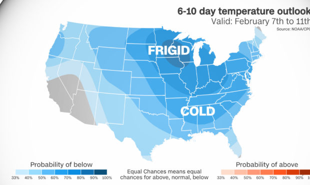
The cold air is here to stay for at least the next week to 10 days. Credit: CNN Weather
(CNN) — It’s about to get so cold that boiling water will flash freeze, frostbite could occur within 30 minutes and it will become a shock to the system for even those who are used to the toughest winters.
The coldest air of the season will be diving south, not leaving anyone out. Every single state in the US — including Hawaii — will reach below freezing temperatures on Monday morning.
Check how cold your low will be Monday.
This includes 86% of the country and 235 million people, and one blast of arctic air is responsible for much of that.
The polar vortex is to blame
This frigid cold is compliments of the polar vortex, a large area of low pressure located near the poles. During the winter months it breaks down, sending cold air that has been bottled up, southward. It can be responsible for extremely frigid temperatures and huge plunges of cold air.
The polar vortex has been weakened even more so this year by the Sudden Stratospheric Warmings that occur about six times a decade.
This will cause the polar vortex to weaken even further, bringing cold air outbreaks to the US, which allows cold air that has been bottled up high int he atmosphere, to be release southward, making for bitterly cold conditions at the surface.
The cold trend will continue for the next 10 days..
A flash freeze to hit the Midwest
The cold air will start diving down through the upper Midwest and Midwest on Saturday. Places in Central Wisconsin could see temperatures plummet to -25F on Sunday, with high temperatures struggling to make it to zero.
It’s a shock for some of the toughest population in the Midwest, when it comes to cold.
“We get 2-3 of these cold snaps every year,” said National Weather Service Office Meteorologist Marcia Cronce. “We are heading into the coldest air of the season, it will feel jolting.”
With highs right around freezing for much of the week, Madison will plummet by the end of the week with a high of only 10 degrees by Saturday. And it’s not just the cold air, the wind plays a big factor too. Wind chills for areas outside Milwaukee could reach 20-30 degrees below zero Saturday and Sunday nights.
This cold air will come on the heels of a wet snow that’s expected on Thursday, which could create even more problems.
“Whatever snow and sloppy precipitation we get on Thursday and Friday, it will freeze quickly,” Cronce said.
“You will have a short time to clear the snow before temperatures drop quickly and the roads freeze rapidly.”
Highs for much of the Midwest will run 15-20 degrees below normal. Chicago will stay in the single digits on Sunday and Monday.
The NWS office in Chicago also warned about the dangerous temperatures in their forecast discussion.
“Bitterly cold to extreme cold air mass arriving over the weekend and continuing into next week, with low temps in some spots 10 below or colder and wind chills of -20F to -30F or even colder possible on Sunday night into Monday,” they say.
If proper clothing isn’t warn, frostbite could occur in as little as 30 minutes.
In fact, 16 states across the Midwest and Northern Plains will experience temperatures below zero on Monday morning. That covers 16% of the country and 41 million people.
Some areas may experience coldest temperatures in years
The cold air will then continue its journey south and east as it spills over much of the South by early next week. There is still some uncertainty about how far south the arctic blast will reach.
Early this week, forecast models were showing places like Atlanta seeing the coldest air since 2018.
“If Monday morning’s low of 19 degrees verifies, that would be the coldest we have been in three years,” said NWS Atlanta Meteorologist Kyle Thiem. Atlanta hasn’t seen temperatures below 20 degrees since January of 2018.
While temperatures in Atlanta will run 15 degrees below normal for this cold air event, it still won’t break records. Atlanta’s record low for February 8 is zero, however, when you factor in the wind chill, the temperature will feel like the single digits.
“Our biggest concerns are people outside for long periods of time,” Thiem said. “We always advise anyone outside to dress in layers and try to take a break and get shelter every 30 minutes or so.”
East Coast to experience temperature swing
Temperatures across the Mid-Atlantic and Northeast will plummet through the day on Monday. Washington, DC, will drop to 16 on Tuesday morning and likely won’t get above freezing for the remainder of the week.
Overnight lows in New York City and Philadelphia will send temperatures into the low teens on Monday morning, with highs only in the low 20s Tuesday afternoon. Boston will drop into the low teens on Tuesday morning and quite possibly won’t get above the 20s for the remainder of the week.
This comes on the heels of Boston experiencing a warmer than normal January and a late start to the snowy season. The weather just might make up for that in February.
The Great Lakes thaw
The Great Lakes have been setting records this winter for the lack of ice. Lake Erie is well below where the lake should be as far as ice concentration goes. The lake is only about 1.6% frozen at the moment, and should be around 60% right now, according to the Great Lakes Environmental Research Laboratory.
The upcoming cold snap will help freeze the lakes a little bit, but it probably won’t help them get to where they should be as far as ice cover goes.
According to NOAA, winter forecasts only estimate the Great Lakes will only get up to about 30% this season, which is far below the average ice concentration, which is 63%.
Significant changes to the amount of ice cover over an extended period of time could have huge implications for the climate of the Great Lakes region. Less ice cover, combined with warmer surface temperatures, will lead to increased lake-effect precipitation in the future.
The-CNN-Wire
™ & © 2021 Cable News Network, Inc., a WarnerMedia Company. All rights reserved.