Hurricane watch issued for Florida’s Gulf Coast as Tropical Storm Idalia approaches
Aug 27, 2023, 6:01 PM
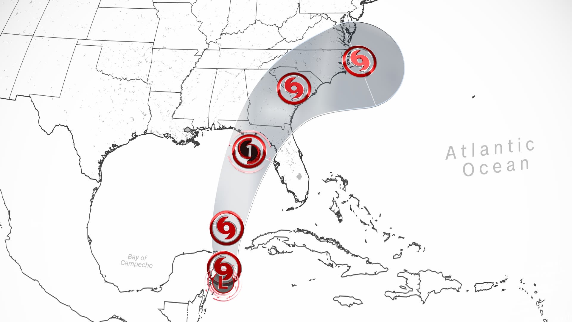
Tropical Depression Ten has formed near the Yucatán Peninsula in the western Caribbean, according to the National Hurricane Center. It could become a hurricane by Tuesday afternoon and make landfall in Florida as early as August 31. (CNN Weather)
(CNN Weather)
(CNN) — A hurricane watch has been issued for portions of Florida’s Gulf Coast as the state braces for Tropical Storm Idalia, which is expected to strengthen to a hurricane and make landfall this week.
Related: How will Hurricane Hilary impact the state of Utah?
The hurricane watch stretches from Englewood to Indian Pass, including Tampa Bay, according to the National Hurricane Center’s Sunday afternoon update. In addition to the hurricane watch, a tropical storm watch has been issued for the Gulf Coast of Florida from Englewood to Chokoloskee and the Dry Tortugas.
The storm is currently located about 100 miles east of Cozumel, Mexico, moving at around 3 mph with maximum sustained winds of 40 mph, the hurricane center said.
Forecasters predict Idalia will slowly traverse the Yucatán Channel over the next 24 to 36 hours, bringing tropical storm conditions to the far eastern portions of Yucatán, Mexico, and the western tip of Cuba through Monday.
Idalia is expected to make landfall on Wednesday morning near the Big Bend of Florida as a Category 2 hurricane.
“Strengthening is forecast, and Idalia is expected to become a hurricane over the southeastern Gulf of Mexico by early Tuesday,” reads the National Hurricane Center’s update. “Additional strengthening is likely while Idalia approaches the northeastern Gulf coast.
Hurricane hunters are probing Idalia for data as the system intensifies.
There is a “notable risk of rapid intensification” as the storm moves through the extremely warm waters in the Gulf of Mexico, the hurricane center noted in an earlier update. Rapid intensification occurs when the maximum sustained winds of a storm increase by 35 mph or more in a 24-hour period.
Idalia is forecast to drop 3 to 6 inches of rain on western Cuba, Florida’s west coast, the Panhandle and southern Georgia, with isolated totals of 10 inches, the hurricane center said. Heavy rainfall may also arrive in parts of the Carolinas by Wednesday and into Thursday.
The heavy rain may lead to flash flooding, the center warned, particularly in western Cuba, the west coast of Florida, the Florida Panhandle and parts of the southeast US.
Life-threatening storm surge, heavy rainfall, and hurricane-force winds are expected in Florida as early as Tuesday. The bulk of the storm is forecast to move over parts of the Southeast on Wednesday.
Florida Gov. Ron DeSantis urged Floridians to “just heed the warnings of your local officials” as the state prepares for Idalia’s arrival.
“Our emergency operations center here in Tallahassee will go to a Level 1, 24-hour around the clock,” starting at 7 a.m. ET Monday, DeSantis said.
In preparation, 1,100 National Guardsmen have been mobilized and they have access to 2,400 high-water vehicles and 12 aircraft for rescue and recovery efforts, DeSantis said. The Florida Highway Patrol also has 300 troopers ready to deploy.
According to the governor, power companies will start staging personnel on Monday.
Schools in Hernando County, north of Tampa, will be closed Monday through Wednesday and voluntary evacuations have been issued for parts of the county, according to a Facebook post. “Residents are advised to seek safe shelter with family or friends that reside in a safe structure. If this is not a possibility, a public shelter will open at 12pm on Monday,” said the county in the post.
President Joe Biden has been briefed on the storm and will continue to receive regular updates as the system heads toward the United States, a White House official told CNN.
Who should pay attention? Anyone living in Mexico’s Yucatán Peninsula, Cuba, and the northern Gulf and Florida coast should monitor the forecast in the coming days. The direction and strength of the upper-level steering winds around this system will dictate where it will move and how quickly.
As of Sunday afternoon, a tropical storm warning is in effect for Yucatán Peninsula from Tulum to Río Lagartos and Pinar del Río in Cuba; a storm surge watch is in effect for Chokoloskee to Indian Pass, Florida; a hurricane watch is in effect for Englewood to Indian Pass, Florida; and a tropical storm watch is in effect for Isle of Youth in Cuba, south of Englewood to Chokoloskee, Florida and Dry Tortugas, Florida.
DeSantis issued an executive order Saturday declaring a state of emergency for 33 counties ahead of the potential inclement weather. “The Governor and the Florida Division of Emergency Management are taking timely precautions to ensure Florida’s communities, infrastructure and resources are prepared, including those communities that are still recovering following Hurricane Ian,” reads a news release announcing the executive order.
When could it affect the US? By Monday, the system will likely enter the Gulf of Mexico, and move toward Florida. It could become a hurricane by Tuesday afternoon and hit the western coast of the Florida Peninsula by Wednesday.
How strong could it get? It’s still too soon to tell how strong this system could get or how fast it could strengthen. But it will be tracking through the warmest waters in the entire Atlantic basin – a vast source of energy for a developing storm. Exceptionally warm water can provide storms the fuel needed to strengthen and sometimes undergo rapid intensification.
Sea surface temperatures are record warm in the Gulf of Mexico and extremely high across the northwestern Caribbean Sea. Water temperatures need to be around 80 degrees Fahrenheit to sustain tropical development, and portions of the Caribbean and Gulf are well above the threshold.
A hurdle to development: Warm water isn’t the only factor at play. The tropical system would also need upper-level winds to cooperate. High wind shear – the wind’s change in direction or speed with altitude – can tear a developing storm apart.
How much wind shear this potential system faces is a critical factor in its formation and final strength. One forecast model shows more wind shear, limiting its development. Another shows less wind shear, allowing the system to develop.
Either way, wind shear may decrease for a time early next week across the far northern Caribbean and eastern Gulf of Mexico, allowing any system that forms to hold together.
Franklin strengthens into hurricane as it heads for Bermuda
Meanwhile, out in the central Atlantic, what was Tropical Storm Franklin strengthened into a Category 1 hurricane with maximum sustained winds of 90 miles per hour, according to a Sunday update from the National Hurricane Center. This was confirmed via aircraft reconnaissance by the NOAA and Air Force Hurricane Hunters.
Hurricane Franklin is currently located 575 miles south of Bermuda and is moving relatively slowly at 8 miles per hour toward the north-northwest.
“Steady strengthening is forecast, and Franklin could become a major hurricane early next week,” said the center in its update. A major hurricane is defined as Category 3 or higher with winds above 111 mph.
“Swells generated by Franklin are expected to begin affecting Bermuda by Sunday night,” the hurricane center said, noting, “these swells are also likely to cause life-threatening surf and rip current conditions late this weekend into early next week along portions of the East Coast of the United States.”
Small variations in Franklin’s track through the weekend will determine exactly how close it gets to Bermuda when it makes its closest pass Monday and Monday night.
Franklin’s winds and rainfall will extend beyond its center. Tropical-storm-force wind gusts are possible across Bermuda early next week as Franklin makes its closest approach. A few showers and thunderstorms are also possible across Bermuda as Franklin passes.
The-CNN-Wire
™ & © 2023 Cable News Network, Inc., a Warner Bros. Discovery Company. All rights reserved.