
First winter storm drops more than 11 inches of snow on Logan
Oct 12, 2021, 1:43 PM
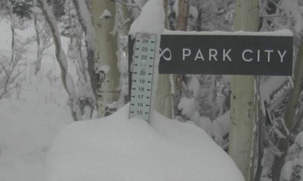
Almost 15 inches at Park City Mountain on 10-12-2021. Photo courtesy of Park City Mountain, Jessie Van der Linden

SALT LAKE CITY — The first winter storm of the season took some Utahns by surprise, while others didn’t see a single snowflake.
The National Weather Service reported Logan received 11-1/2 inches of snow, dropping tree limbs onto power lines. Logan received slightly more snow than Solitude ski resort.
Park City Mountain resort is reporting the biggest snowfall with almost 15 inches. The valleys along the Wasatch Front saw only rain.
Utah snow totals so far Tuesday:
❄️11.5″ Logan
❄️11.0″ Solitude
❄️7″ Cedar City
❄️4″ Enoch
❄️3.3″ Park City
❄️2.7″ Newcastle
❄️1.8″ Oakley
❄️1.5″ Oak City
❄️1.0″ KanabMore reports in the link! #utwx https://t.co/hTJF8FYp8c
— NWS Salt Lake City (@NWSSaltLakeCity) Oct. 12, 2021
Southern Utah also has a white blanket
The Interstate 15 corridor between I-70 and Cedar City was nearly a whiteout early Tuesday morning, according to KSL Meteorologist Grant Weyman. Central and Southern Utah will likely pick up more snow throughout the day.
“Now the target is southwestern Utah. So, beyond Beaver toward Cedar City. The mountain passes can be an issue whenever there’s winter weather,” said Weyman.
Cedar City already picked up 7 inches of snow by 9 a.m. New Harmony in Washington County reported 10 inches.
Zion National Park said it had to close the Kolob Canyons Road due to weather conditions.
More updated snow totals across the state.
A few new ones:
❄️10″ New Harmony
❄️6″ Timber Lakes
❄️5″ Richfield
❄️3″ Fremont Indian SP
❄️3″ S Torrey
❄️3″ Scofield
❄️1.5″ LoaMore in the link below! #utwx https://t.co/JKIIIt4CF3
— NWS Salt Lake City (@NWSSaltLakeCity) October 12, 2021
Not done yet
Weyman said this storm is “slowly churning across the state.” He said more rain is expected at lower elevations with higher elevations getting more snow.
Mostly sunny skies return on Wednesday.
“Then a colder storm moves in Wednesday night and Thursday, bringing more rain and snow,” said Weyman.


