Hurricane Lee is charting a new course in weather and could signal more monster storms
Sep 9, 2023, 1:00 PM
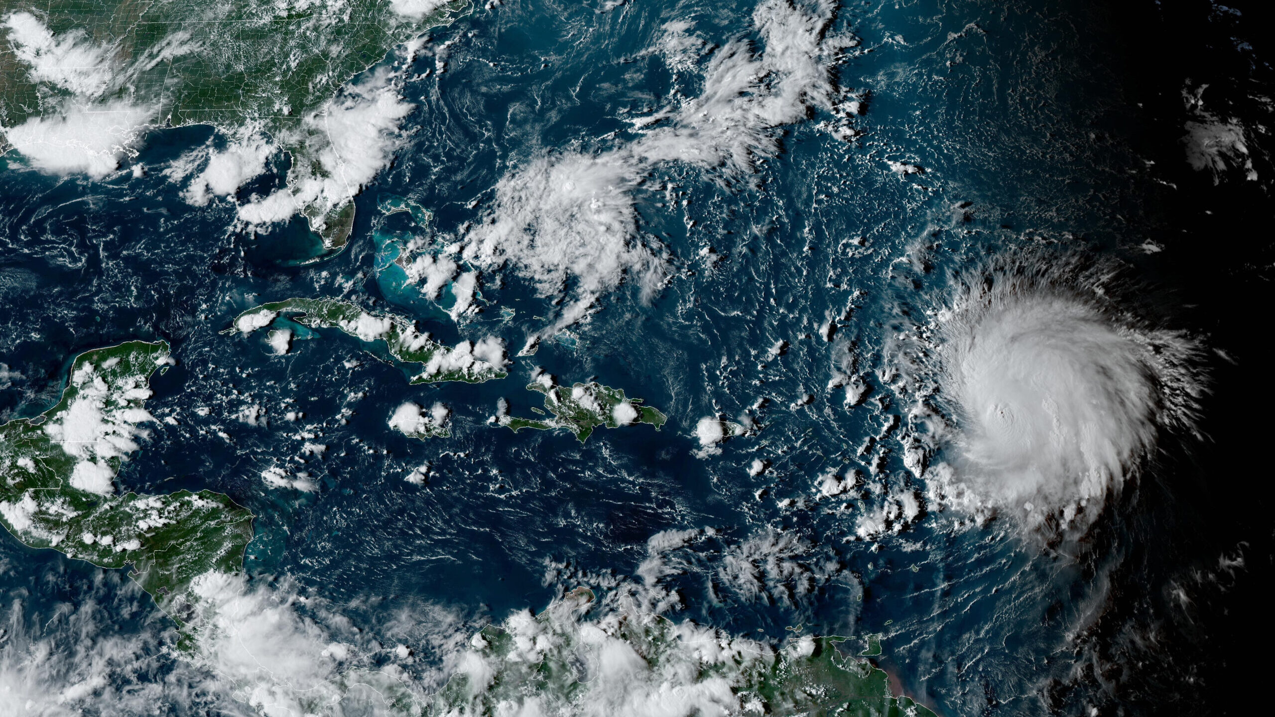
This satellite image provided by the National Oceanographic and Atmospheric Administration shows Hurricane Lee, right, in the Atlantic Ocean on Friday, Sept. 8, 2023, at 4:50 p.m. EDT. Lee is rewriting old rules of meteorology, leaving experts astonished at how rapidly it grew into a goliath Category 5 hurricane. (NOAA via AP)
Credit: ASSOCIATED PRESS
(NOAA via AP)

ATLANTA (AP) — Hurricane Lee is rewriting old rules of meteorology, leaving experts astonished at how rapidly it grew into a goliath Category 5 hurricane.
Lee — which just as quickly dropped to a still-dangerous Category 3 and held that strength Saturday — could still be a harbinger as ocean temperatures climb, spawning fast-growing major hurricanes that could threaten communities farther north and inland, experts say.
“Hurricanes are getting stronger at higher latitudes,” said Marshall Shepherd, director of the University of Georgia’s atmospheric sciences program and a past president of the American Meteorological Society. “If that trend continues, that brings into play places like Washington, D.C., New York and Boston.”
Hyperintensification
As the oceans warm, they act as jet fuel for hurricanes.
“That extra heat comes back to manifest itself at some point, and one of the ways it does is through stronger hurricanes,” Shepherd said.
During the overnight hours Thursday, Lee shattered the standard for what meteorologists call rapid intensification — when a hurricane’s sustained winds increase by 35 mph (56 kph) in 24 hours.
“This one increased by 80 mph (129 kph),” Shepherd said. “I can’t emphasize this enough. We used to have this metric of 35 mph, and here’s a storm that did twice that amount, and we’re seeing that happen more frequently,” said Shepherd, who describes what happened with Lee as hyperintensification.
With super-warm ocean temperatures and low wind shear, “all the stars were aligned for it to intensify rapidly,” said Kerry Emanuel, professor emeritus of atmospheric science at the Massachusetts Institute of Technology.
Inland threats
Category 5 status, when sustained winds are at least 157 mph (253 kph), is quite rare. Only about 4.5% of named storms in the Atlantic Ocean have grown to a Category 5 in the past decade, said Brian McNoldy, a scientist and hurricane researcher at the University of Miami.
More intense major hurricanes also are threatening communities farther inland, because the monster storms can grow so powerful that they remain dangerous hurricanes for longer distances over land.
“I think that’s a story that’s kind of undertold,” Shepherd said. “As these storms are strong coming to landfall, in some cases they’re moving fast enough that they’re still hurricanes well inland.”
Hurricane Idalia was the latest example. It came ashore in the Florida Panhandle last month and remained a hurricane as it entered south Georgia, where it slammed into the city of Valdosta more than 70 miles (116 kilometers) from where it made landfall. At least 80 homes in the Valdosta area were destroyed and hundreds of others damaged.
In 2018, Hurricane Michael carved a similar path of inland destruction, tearing up cotton crops and pecan trees and leaving widespread damage across south Georgia.
Monster waves
Although it’s too early to know how close Lee might come to the U.S. East Coast, New Englanders are keeping a wary eye on the storm. As it creeps closer, it could bring high seas and rip currents up and down the Eastern Seaboard.
“What we are going to see from Lee — and we’re very confident — is it’s going to be a major wave producer,” Mike Brennan, director of the National Hurricane Center, said in a Friday briefing.
On Saturday, large swells battered the northeast Caribbean as Lee churned through open waters hundreds of miles off the northern Leeward Islands.
“This morning, the highest significant wave height we were analyzing in Lee was between 45 and 50 feet, and the highest waves could even be double that,” Brennan said, speaking of swells far out at sea. “So we could be looking at 80, 90-foot waves associated with Lee.”