
Satellite images from NASA show water loss at Lake Mead since 2000
Jul 22, 2022, 1:30 PM | Updated: Aug 2, 2022, 10:23 am
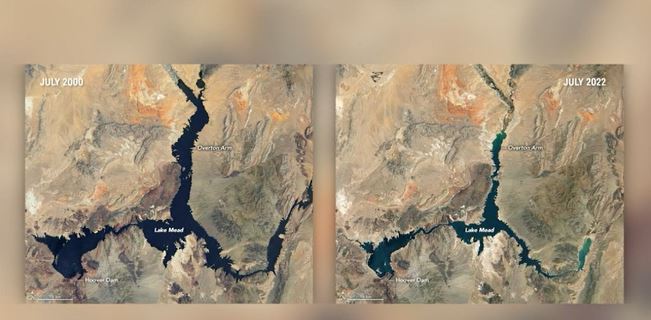
Side by side images, released by NASA, showing dramatic water loss of Lake Mead between 2020 and 2022. (Screen grab, CNN)
(Screen grab, CNN)
Click here for updates on this story
LAS VEGAS, Nevada (KVVU) — NASA has released new satellite images that show the rapid decline of water at Lake Mead since 2000.
In the release of the photos, NASA noted that water levels at Lake Mead currently stand at the lowest since April 1937, when the reservoir was still being filled for the first time.
As of July 18, according to NASA, Lake Mead was filled to just 27% of capacity.
Additionally, also as of July 18, NASA says the water elevation at the Hoover Dam was 1041.30 feet above sea level; the water elevation at the end of July 2000 was 1199.97 feet.
“Lake levels at the dam should stay above 1000 feet to continue operating hydropower turbines at normal levels,” NASA said.
Lake Mead provides water to roughly 25 million people in Arizona, Nevada, California and Mexico.
The-CNN-Wire
™ & © 2022 Cable News Network, Inc., a WarnerMedia Company. All rights reserved.
Related reading:
- Drought sinks Lake Mead to an unprecedented low
- Lake Powell to receive a boost in water supply
- Lake Powell water levels could mean trouble for Southern Utah’s electricity


